On Day 3 of your travel program, you transfer to the Hershey Harrisburg Region – 2 nights 3 Days.
The Susquehanna River is 464 miles (747 km) long and is the longest river on the US East Coast. With its watershed, it is the 16th-largest river in the United States, and the longest river in the continental United States without commercial boat traffic today. In the Canal Era, navigation improvements were made to enhance the river for barge shipping of bulk goods by water on the Pennsylvania Canal.
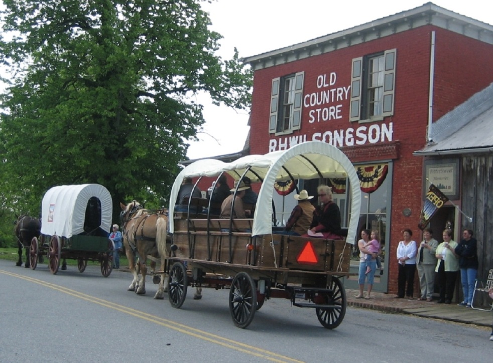
 Harrisburg, the Capital of Pennsylvania, was inhabited by Native Americans as early as 3000 BC. Known as Peixtin, the area was an important trading post for Native American traders, as trails leading from the Delaware to the Ohio Rivers, and from the Potomac to the Upper Susquehanna intersected there.
Hershey is a year-round, world class travel destination with an amusement park, exclusive resorts and family attractions. In 1906, Milton Hershey opened Hershey Park as a place where his chocolate factory’s workers and their families could relax and be entertained. Surrounded by some of America’s most productive dairy farms, the world’s first modern chocolate factory and model town is a real community.
City Island is a 63-acre tourism and recreational destination containing archeological treasures of the Susquehannocks and Iroquois tribes which established seasonal settlements here. The island was a stopping off-point for Union soldiers during the Civil War; they crossed over it by way of the Camelback Bridge to defend Harrisburg from the threat of invasion by the Confederate Army. Today, City Island is a tourist destination which is home to numerous businesses including the Harrisburg Senators Baseball Stadium, the City Islanders Soccer Stadium, the Pride of the Susquehanna, Island Breezes Gift Shop, Susquehanna Outfitters, H20 Miniature Golf, City Island Arcade/Batting Cages, City Island Railroad, and the City Island Stables.
Millersburg Borough nestled along the Susquehanna River, is quaint community radiating out from a Victorian Market Square Park featuring a Gazebo dating back to 1891. Millersburg evolved along with the introduction new forms of transportation; travel back to the 17th century and visit the Wiconisco Canal in MYO Park and a restored 1898 passenger rail station on West Center Street. The National Historic Register’s Millersburg Ferry System traces its roots to 1817.
 Preserving America’s Antique Automobiles
The Antique Automobile Club of America Museum in Hershey, Pennsylvania opened its doors in June 2003, with over 100 cars, motorcycles plus memorabilia, collectibles, and special exhibits. Vehicles of all types 25 years or older are welcome in the AACA. In 1993, the AACA started a nonprofit organization to further preserve these antique automobiles and educate the public.
Susquehanna Art Museum is the cultural anchor for the Central Pennsylvania community, providing innovative, relevant and engaging exhibitions and experiences for members and visitors of all ages that excite, inspire, and stimulate life-long learning.
Union Canal Tunnel Park was designated a National Historic Civil Engineering Landmark in 1970 and received its recognition as a National Landmark in 1994. Open dawn to dusk for hiking, bird watching, picnics, and recreation.
The U.S. Army Heritage and Education Center (USAHEC) is the premier facility for historical research on U.S. Army history and is dedicated to “Telling the Army story…one Soldier at a time.” The expansive campus includes the Visitor and Education Center, the U.S. Army War College Library, the U.S. Army Military History Institute, and the Army Heritage Trail. Open to the public, key features of the USAHEC include interpretive and interactive exhibits, the research library and archive.
Army Heritage Trail the mile-long outdoor Army Heritage Trail allows visitors to experience history in a new way, through interactive and full-scale military exhibits. Exhibits include a Cobra helicopter, Civil War encampment cabins, WWI trench system and more highlighting the different eras of American military history. The trail is open from dawn to dusk.
The National Civil War Museum seeks to tell the whole story of this most troubled chapter in American history, focusing on the issues, the people and the lives that were affected. The causes and ramifications of this conflict that divided a Nation are investigated; both Northern and Southern viewpoints are presented; and military as well as civilian perspectives are highlighted.
The State Museum of Pennsylvania presents the State’s heritage from the Earth’s beginnings to the present. Archaeological artifacts, decorative arts, fine art galleries and industrial and technological innovations are on exhibit. The Civil War exhibit includes the 1870 painting “The Battle of Gettysburg: Pickett’s Charge”. Curiosity Connection is a hands-on learning environment for children. Other features: a Planetarium, Mammal Hall, Dino Lab and a restored Marshall’s Creek Mastodon Skeleton.
Gettysburg Museum of the American Civil War has twelve exhibit galleries featuring artifacts, interactive displays and several films that will further immerse you in the Battle of Gettysburg and the larger context of American history and understanding its relevance in our lives today.
The Amish Village provides an authentic experience, beginning with a guided tour of an Amish farmhouse. Explore a 12-acre village, complete with a one-room schoolhouse, local crafts and treats, blacksmith barn, animals and more.
The Pennsylvania Capitol is a National Historic Landmark and Palace of Art. The dome is a 1/3 replica of Saint Peter’s Basilica in Vatican City and the grand staircase inside the main rotunda was inspired by the opera house in Paris.
Pride of the Susquehanna River Boat is one of the last remaining authentic paddle-wheel riverboats in America. Since her construction and launch in 1988, “The Pride” has carried almost a million passengers who have enjoyed themed cruises and River School Educational Trips.
 Food Wine and Craft Beer
Turkey Hill, located in nearby Lancaster County, features interactive exhibits allowing you to learn about dairy culture, how the company’s ice cream and iced tea flavors are selected and created, as well as a chance to create your own virtual ice cream flavor; free tastings!
The Millworks is a local and sustainable restaurant, bar with an outdoor biergarten, art galleries with 23 artist studios, & a live music venue located in the heart of Harrisburg’s Midtown District including the Broad Street Market; Susquehanna Museum of Art; and Midtown Scholar Bookstore.
The Wineries and Breweries of the Hershey Harrisburg Region invite guests to go beyond just tasting the wines. Learn more about the process and walk away with a deeper appreciation of winemaking and Pennsylvania’s agricultural heritage. Experience the rich tastes of each winery’s blends, ciders and specialty collections. The region is also home to many small batch brewers who are following their dreams and creating trendy, welcoming spaces for beer-lovers to appreciate their favorite brews.
 US Mid-Atlantic Travel an eight-day program for Families Schools and Groups
Philadelphia, Hershey, Harrisburg, Washington DC, Maryland Brandywine Valley
Shared Mobility Calculator Intercity Travel Costs US Trip Planner

41.123009
-75.965276


 Lafayette lies along the Vermilion River in southwestern Louisiana and is nicknamed The Hub City
 Local Cultural Organizations include the Acadiana Symphony Orchestra and Conservatory of Music, Chorale Acadienne, Lafayette Ballet Theatre and Dance Conservatory, The Lafayette Concert Band, and Performing Arts Society of Acadiana; as well as the Paul and Lulu Hilliard University Art Museum and the Acadiana Center for the Arts.
 Amtrak’s Sunset Limited offers service three days a week from New Orleans and Los Angeles with selected stops in Louisiana, Texas, New Mexico, Arizona and California. Intercity passenger bus service is via Greyhound that operates a Station Downtown and Lafayette Transit System provides bus service within Lafayette City Limits.
 Connect for Your Travel to Lafayette and Louisiana

 Origins built in 1794 by General Anthony Wayne as the last in a series of forts built near the Miami village of Kekionga, this European-American settlement developed at the confluence of the St. Joseph, St. Mary and Maumee rivers and later underwent growth with the Wabash and Erie Canal and the railroad. The term Summit City refers to the city’s position at the highest elevation along the canal’s route.
 Geography the most important feature of the area is the short distance overland between the Three Rivers system, which flows to the Atlantic, and the Wabash system, which flows to the Gulf of Mexico; hence, the portage over which passengers and cargoes moved from one system to the next. This natural crossroads attracted the Native Americans for thousands of years. Chief Little Turtle of the Miami Nation called it “that glorious gate through which all the words of our chiefs had to pass through from north to south and from east to west.” It later attracted explorers, traders and pioneer settlers who continued to develop the area as a transportation and communications center.
 Architecture during the 19th century, Fort Wayne was dominated by Greek and Gothic Revival as well as Italianate architecture. Popular early-20thcentury architectural styles found in the city include Queen Anne, Romanesque, Neoclassical, Dutch Colonial Revival, Prairie, Tudor Revival and Art Deco.
 Arts and Culture since its establishment in 2010, the Cultural District has been home to several of the city’s cultural institutions, including the Auer Center for Arts and Culture, the Arts United Center, and Hall Community Arts Center. The Embassy Theatre hosts over 200,000 patrons annually and Foellinger Theatre hosts seasonal acts and outdoor concerts during warmer months. Located west of downtown, Arena Dinner Theatre is a nonprofit community arts corporation with a focus on live theater production, annually hosting seven full-length theatrical productions. Established in 1921, the Fort Wayne Museum of Art specializes in the collection and exhibition of American art.
 River Greenway is a system of recreational trails along the riverbanks designed to beautify the riverfronts and promote an active lifestyle for Fort Wayne residents. It comprises 180 miles (290 km) in the city and county and has about 550,000 annual users. With the expansion of trails, cycling has also become an emerging mode of transportation for residents.
 Connect for Your Travel to Fort Wayne and Indiana
 The Rockpile Museum documents life in early Gillette. After the railroad moved to Sheridan, Gillette survived in order to serve the ranchers, cowboys, and homesteaders who were trying to make a life in the countryside surrounding the town. Cattlemen drove their herds into the livestock yards at Gillette for sale and transportation to the markets back east. Industrious citizens set up businesses to cater to these people and any who passed through. Livery barns, stables, and blacksmiths popped up to house travelers’ horses and haulers’ draft teams. Bars and brothels catered to those who pursued that lifestyle.
 Tourism Gillette’s inclusion on the Black and Yellow Trail in 1912, a highway extending from the Black Hills to Yellowstone, brought many different travelers and tourists into town via automobile resulting in construction of tourist camps, cottages, and motels along with cafes and eateries.
 Geography Gillette is situated between the Bighorn Mountains and the Black Hills in the Powder River Basin. Devils Tower rises 1,267 feet – 386 m – above the Belle Fourche River; the summit is 5,112 feet – 1,559 m – above sea level.

 Ardmore is the word for Hills or High Grounds in Irish
 Geography Ardmore is located south of the Arbuckle Mountains, an ancient, eroded range spanning some 62 mi – 100 km – across southern Oklahoma. The geology includes uplifted and folded ridges visible within the shoreline of some of the surrounding lakes. The city of Ardmore is part of the Washita and Red River watersheds, just north of Lake Murray which flows into the western reaches of Lake Texoma.
 Connect for Travel to Ardmore
 Sustainable Communities are created by addressing resource protection climate change air and water quality human health and well-being
 urbanization, traffic gridlock, population increases, community migrations
 Governments at all levels are engineering political solutions:
 At the dawn of the 20th Century only 14 percent of the world’s population lived in cities; by 2025, 75 percent will be in urban settings. There are already 468 cities with over a million in population; 40 of these cities have more than 10 million residents.

 Adaptable Rice is the basic food for nearly half of the world’s population, it can be kept for a very long time and in the case of famine, can be a lifesaving food source. In some cultures, it is as valuable as money or gold and is an essential commodity for those living in tropical and sub-tropical climates.
 Fruits and Vegetables contain a large variety of plants with different shapes, scents and colors. Fruits and legumes have been consumed for centuries and are the symbols of myths, legends and traditions in many cultures. Cultivation began in the Mediterranean region, mainly due to it having the best climate to grow and cultivate fruits; the Egyptians, Greeks and Romans were knowledgeable of these foods but it was only from the medieval period that improvements in fruit cultivation took hold. Later, immigrants brought fruit and legumes to the American continent, resulting in their widespread cultivation. Soya and beans were found in Central and Southern Asia and in Central America respectively.
 Spice Routes have guided explorers in their search for these precious commodities; a journey through cultures and a unique sensorial experience. Their cultivation, preparation and use is also tied to medicine and for socio-cultural rituals, including magic. Spices and aromatic herbs have always inspired long journeys; emperors, kings, aristocrats and merchants considered them into the most luxurious product of the ancient commercial routes. In our time, spice production and trade have increased thanks to a trend in healthier eating habits.
 Food without Water the arid zones are quite different from one another. They differ in soil types, flora and fauna, water balance and levels of human activity. Another misconception is that these places are uninhabited when in fact a fifth of the world’s population live in arid zones and suffer from a distinct lack of water. What makes then similar is dryness, measured by weather temperature and rainfall. This index consists of three main categories: super dry, dry and semi-dry. For centuries, man has tried to promote and utilize different techniques in order to find one system for managing hydric sources, such as rainwater collection or water retention. Research has enabled farmers to measure their levels of rainfall locally and either use innovations suited to their conditions, or adapt their own traditional methods to ensure better water utilization levels. Still, the lack of water and the impact of climate change remain a matter of urgency.
 Logistics the success of a business trip or vacation rests largely on the proper management of logistical issues; how to get to a place and how to get around once you are there are the keys to staying within budget while visiting all the places planned along your route.
 the less time in transit the more time on your vacation the less stressful your trip
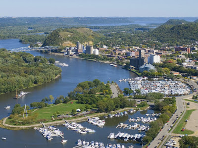 Solutions the travel expert who is tasked with planning, implementing and managing your trip is intimately familiar with the places you are visiting and, by definition, is also able to make adjustments and changes to your travel program even when you are on location. A successful trip is defined as:

