Atlantic Coast · canals · Conservation · Cultural Heritage · cultural itineraries · destination management · food and wine itineraries · Friends and Family Travel · Historic Towns · intercity transit · museums · Tradition · travel plan · waterways · Wine Trails

Mid-Atlantic Rivers Canals and Trails

in the Hudson Delaware and Susquehanna Valleys

The Hudson Valley extends 150 miles above the tip of Manhattan. Designated as a National Heritage Area, the valley is steeped in history, natural beauty, culture, food and farmers’ markets. The first Dutch settlement was established at Fort Nassau, a trading post south of present-day Albany, in the early 17th century, with the purpose of exchanging European goods for beaver pelts. During the French and Indian War in the 1750s, the northern end of the valley became the bulwark of the British defense against French invasion from Canada via Lake Champlain.The valley also became one of the major regions of conflict during the American Revolution.

Dutchess County is 800 square miles of natural scenic beauty, historic and cultural landmarks, and outdoor recreation. Stroll the Walkway Over the Hudson. Tour and taste along the Dutchess Wine Trail. Explore the homes of FDR and Vanderbilt. Taste new creations at The Culinary Institute of America. Fill the pantry at farm markets. Cruise the Hudson River. 

Rockland County is located just 30 miles north of New York City and is known for its quaint villages, spectacular river views and outdoor recreation with 32,000 acres of parklands dotted with sparkling lakes and streams rushing down to the Hudson. Miles marked trails lead right to the foothills of the Ramapo Mountains. 

Coal Iron Steel and Canals of the Delaware and Lehigh Valleys

The Delaware and Lehigh five county region of Northeastern Pennsylvania developed in the late 18thCentury as a result of the anthracite mines, the iron and steel industries, and the canals that were built to reach Philadelphia and other markets. 

165 miles of nature history preservation recreation and education

From its origins as a means to transport anthracite coal from the mines of Luzerne and Carbon County to the markets in the Lehigh Valley and Philadelphia, the D&L Trail is now a multi-use trail originating from the mountains of northeast Pennsylvania through the rivers and communities of the Lehigh Valley and Bucks County. 

Philadelphia the Brandywine Valley and Wilmington Delaware

In Philadelphia, the waterfront is now a walking and biking destination which covers 6 miles. Trail features include streetscape improvements along the entire waterfront trail, a bi-directional bikeway, pedestrian walkway and rain gardens that will collect the first inch of storm water, relieving the city sewer system during major weather events, as well as benches and bike racks, decorative street pavers, and innovative solar trail lighting.

The Christina Riverfront is one of many reasons for exploring the Delaware culture trail; cruise in a water taxi or stroll the landscaped Riverwalk. Wilmington was the last stop to freedom on the Underground Railroad; the Tubman-Garrett Riverfront Park is named for Underground Railroad Conductor Harriett Tubman and Stationmaster Thomas Garrett.

Brandywine Creek is a tributary of the Christina River in southeastern Pennsylvania and northern Delaware. The 20.4-mile Lower Brandywine is a designated Pennsylvania Scenic River with several tributary streams.

Harrisburg and the Susquehanna River Valley

The Susquehanna River is 464 miles (747 km) long and is the longest river on the US East Coast. With its watershed, it is the 16th-largest river in the United States, and the longest river in the continental United States without commercial boat traffic today. In the Canal Era, navigation improvements were made to enhance the river for barge shipping of bulk goods by water on the Pennsylvania Canal.

Harrisburg, the Capital of Pennsylvania, was inhabited by Native Americans as early as 3000 BC. Known as Peixtin, the area was an important trading post for Native American traders, as trails leading from the Delaware to the Ohio Rivers, and from the Potomac to the Upper Susquehanna intersected there.

An Architectural and Heritage Itinerary

Downtown Lancaster offers a unique experience with historic buildings of different architectural styles and periods and three centuries of civic, commercial, religious, social and architectural history. A leisurely walk can be accomplished in less than an hour. 

Reduce Transit Times and Travel Costs on Your Next Trip

Travel Plans     Intercity & Local Transport

Atlantic Coast · canals · Cultural Heritage · cultural itineraries · destination management · food and wine itineraries · Friends and Family Travel · Historic District · Historic Towns · intercity transit · Lakes · museums · Rivers · Travel · travel plan · waterways · Wine Trails

Environmental and Historical Tourism

Food Wine and Craft Beer Trails in US North East Towns

The Northeast Region of the United States corresponds to the original northern colonies that founded the country. Besides its illustrious history and culture, the region is a trend setter on the technological and environmental fronts along with agricultural innovations and unique, local food, wine and craft beer traditions.

Vermont is agriculture and industry, heritage museums and historic sites, small towns and downtowns where visitors and residents find the distinctive local businesses, historic buildings, and rich cultural and social activities that form Vermont’s special sense of community. These authentic and attractive downtowns and villages are widely recognized as a key part of the state’s allure.

Rockland and Piermont are located just 30 miles north of New York City and are known for quaint villages, spectacular river views and outdoor recreation with 32,000 acres of park lands dotted with sparkling lakes and streams rushing down to the Hudson. Miles marked trails lead right to the foothills of the Ramapo Mountains. The Hudson Valley extends 150 miles above the tip of Manhattan; a National Heritage Area the valley is steeped in history natural beauty culture food and farmers’ markets.

Upstate New York is home to city and country settings, high-tech industries and natural wonders. Drive through the Catskill Mountains and reach the Corning Museum, the world’s largest glass museum featuring a contemporary art and design wing; experience live hot glass demonstrations of glass objects made by artists and hands-on exhibits highlighting science and technology.

The Finger Lakes and Watkins Glen State Park, site of 19 waterfalls and a gorge. Seneca Lake is a long slender lake with wineries along both sides. From Geneva, on the north shore of the lake, you can head east towards Syracuse and visit Destiny USA, sixth largest shopping destination in the United States.

Rochester is a world-renowned American city and home to George Eastman House International Museum of Photography and Film inside the home of Kodak’s founder.

Cruise or Walk though Historic Villages along the Erie Canal

North East Atlantic Travel Destination Services

Travel Plans     Intercity & Local Transport

Environmental Tourism

Some communities have been in the forefront of land conservation, historic preservation and arts movements that celebrate the land, landscapes and water resources management initiatives. 

Local Culture in the Lehigh Valley draws from the Moravian settlements experience, a broad cultural environment in which music, art, education and religious tolerance flourished, as evidenced by the communal dwellings, churches and industrial structures.

The Brandywine Valley facing an industrial development that would impact a largely rural community, focused on Development & Conservancy Issues, including floodplain areas that threatened to devastate water supplies in parts of the Delaware River Valley. 

In Philadelphia the waterfront is now a 6-mile walking and biking destination. Trail features include streetscape improvements, a bi-directional bikeway, pedestrian walkway and rain gardens that collect the first inch of storm water, relieving the city sewer system during major weather events, along with benches, bike racks, decorative street pavers and innovative solar trail lighting.

Center City offers a thriving culture and entertainment scene as well as a contemporary arts museum with training programs and study tours for students, aspiring artists and traveling families.  

Historical Tourism

Bucks County is one of the three original counties created by William Penn in 1682. Pennsbury Manor stands on the point of land formed by the Delaware River between Morrisville and Bristol. Painstaking research went into restoring the prim-fronted, three-storied, brick manor-house, rebuilt on the original foundations.

Lehigh Valley Allentown was a rural village founded in 1762 by William Allen, Chief Justice of Colonial Pennsylvania’s Supreme Court. By 1829 Allentown expanded from a small Pennsylvania Dutch village of farmers and tradesmen to a center of commerce. With the opening of the Lehigh Canal, many canal workers made their homes here. 

The Lehigh Valley Gave Birth to America’s Industrial Revolution

Loudoun County Virginia is renowned for rolling hills of farms and vineyards, pastures filled with grazing horses, and the Blue Ridge Mountains; it is also just 25 miles from Washington DC.

Leesburg has seen significant history from 1758 and has a well-preserved downtown historic district with stunning 18th and 19th century architecture. It also a shopping and dining venue and features historic sites such as Gen. George C. Marshall’s home, Dodona Manor and Ball’s Bluff Civil War battlefield.

Middleburg, known as the capital of Virginia’s horse country, has been welcoming visitors since 1787. It is also a shopper’s delight, with home furnishing and antique stores, boutiques and more; a stroll through this historic hamlet is a unique experience. Middleburg has hosted iconic American personalities such as Jackie Kennedy and F. Scott Fitzgerald.

  history geology hydrology fishing and the environment

The Eastern Shore of Maryland is comprised of nine counties with a population of nearly 450 thousand. The term Eastern Shore distinguishes a territorial part of the State from the land west of Chesapeake Bay. The Chesapeake and Delaware Canal was a shallow canal with locks after its construction in 1829; it was deepened in the early 20th century to sea level. The north-south section of the Mason-Dixon Line forms the border between Maryland and Delaware.

Environmental and Historical Tourism in the US North East

Atlantic Coast · Cultural Heritage · cultural itineraries · destination management · food and wine itineraries · Friends and Family Travel · Historic District · Historic Towns · intercity transit · museums · Tradition · Travel · travel plan

Heritage Tourism in the American South

Cowboys Cowgirls Music and Culinary Traditions

The American South is comprised of 14 States from Oklahoma and Texas to the Gulf Coast and South Atlantic port cities and from the Ohio and Mississippi Rivers to New Orleans.

Historical Tourism and Victorian Architecture

Guthrie lies along one of the primary corridors into Texas and Mexico and is a four-hour drive from the Dallas-Fort Worth metropolitan area. The city is in the center of the state, about 32 miles – 51 km – north of Oklahoma City, in the Sandstone Hills region of Oklahoma, known for hills and oak forests

Dallas is relatively young city with a colorful past. In 1839, John Neely Bryan, a lawyer from Tennessee with a taste for adventure, wandered into the area and was impressed with what he believed to be the perfect ingredients for a trading post and eventually a town: plenty of raw land, Indians with whom to do business, and the river. The young city’s can-do spirit helped bring railroads in the 1870s, the Federal Reserve Bank in 1914, Southern Methodist University in 1915, Love Field Airport in 1927, the Texas Centennial Exposition in 1936 and DFW International Airport in 1973.

Fort Worth was settled in 1849 as an army outpost along the Trinity River as one of eight forts assigned to protect settlers on the advancing frontier. The cattle industry was king for a generation of people working the Fort Worth leg of the historic Chisholm Trail, which ran from the 1860s to the 1870s when the Texas & Pacific Railway arrived. In the years that followed, oil and aviation brought new wealth throughout the region. The post-war years found Fort Worth capitalizing on its strengths as a transport, business and military center. Cultural pursuits included the development of the city’s internationally acclaimed museum district.

Texas Cities and the Hill Country Austin, on the eastern edge of Texas Hill Country, is the state capital, the live music capital of the world, a center for film, home to the University of Texas and Formula 1’s Circuit of the Americas raceway. The city’ parks and lakes are popular for hiking, biking, swimming, boating and other outdoor pursuits as well as a ballet, museums and unique shopping experiences.

San Antonio’s rich heritage includes 18th century Spanish colonial missions, residential areas dating from the 1860s and local museums that celebrate the city’s past. The San Antonio Mission Trail begins at the Alamo and winds southward along a nine-mile stretch of the San Antonio River.

New Orleans was established by the French in 1718 at a location that continues to be a valuable site for trade due to its strategic position along the Mississippi River. The French Quarter is a National Historic Landmark and is bordered by Canal, Decatur and Rampart Streets and Esplanade Avenue. It boasts cultural contributions from the French, Spanish, Italians, Africans and Irish.

Reduce Transit Times and Travel Costs on Your Next Trip

Travel Plans     Intercity & Local Transport

Mobile Alabama is located at the head of Mobile Bay and the Central Gulf Coast. Founded by the French in 1702, during its first 100 years, Mobile was a colony of France, Britain and Spain; it became a part of the United States of America in 1813. 

Savannah was founded in 1733 on the Savannah River, it became the colonial capital and later the first state capital of Georgia. Its port was of strategic importance during both the American Revolution and the Civil War. 

Charleston was founded in 1670, Charleston is defined by its cobblestone streets, horse-drawn carriages and pastel pre-Civil-War-era houses, particularly in the bustling French Quarter and Battery areas. The Battery promenade and Waterfront Park both overlook Charleston Harbor, while Fort Sumter, a Federal stronghold where the first shots of the Civil War rang out, lies across the water. 

Charlotte is named in honor of King George III of Britain’s consort. It is a city with 199 neighborhoods and many nicknames, including: the famed Hornet’s Nest derived from the American Revolution, The QC, Crown Town, Home of NASCAR, Gem of the South, CLT, Bank Town, Char-Town and City of Trees.

Asheville has a fascinating past; experience a walking itinerary that commemorates the city’s most significant cultural, educational, social and architecture stories; a museum without walls. Urban Farm and Mountain Trails Gourmet Cuisine Public Art Music Heritage and a Bohemian Culture.

Louisville is centrally located along the Ohio River and is one America’s most accessible cities within a day’s drive of more than half the nation’s population. This city has a colorful past, from its frontier founding at the time of the American Revolution, to early 19thcentury steamboats and as a Union base during the Civil War. Named for King Louis XVI of France in appreciation for his assistance during the Revolutionary War, Louisville was founded by George Rogers Clark in 1778.

Nashville has been the subject of many books, movies and songs. But, while music is the lifeblood of this city, you will also find here culture, history, haute cuisine, sports, natural beauty and especially Southern charm.

Memphis is a city with a rich and eclectic history. Some of the city’s traditions and milestones: the home of Elvis Presley, the Memphis Zoo, the Indie Memphis Film Festival, Sun Studio, National Civil Rights Museum, Stax Museum of American Soul Music and the Beale Street Music Festival.

The Sights Sounds and Culinary Traditions of the Mississippi Regions. A melting pot of cultures, a mighty river, antebellum mansions and restaurants featuring soul food, authentic ethnic dishes and modern culinary delights. The tastes of this region take their influences from Native American heritage.

a melting pot of regional, ethnic, national and international cuisine

Atlantic Coast · Cultural Heritage · cultural itineraries · destination management · food and wine itineraries · Historic Towns · intercity transit · museums · Tradition · Travel · travel plan · Wine Trails

Prince William County Virginia

American Historic Small Towns Itineraries

A Civil War experience at the Manassas National Battlefield Park, Family Arts and Entertainment, History at the National Museum of the Marine Corps, National Parks and the Outdoors, Antique Shops, Cafes, Restaurants, Art Stores and Boutiques in:

Bristow most of the area was previously part of the Linton’s Ford Plantation, owned by the Linton Family from the 18th century. In 1894, Sarah Linton converted to Catholicism, the property was deeded to the Roman Catholic Church and the Linton Hall School was founded; in the late 20th century, much of the original property was sold to developers to raise money to support the school.

Dumfries the largest town in Prince William County was chartered in 1749. It is named for a town in Scotland from where a locally prominent merchant hailed. It grew in wealth and importance as a tobacco port rivaling New York and Boston; soil erosion and silting ended the trade. Today, Dumfries is known as the oldest continually chartered town in Virginia, home to the Weems-Botts Museum and as keeper of much of our Nation’s early history.

Gainesville was once a changing point for stagecoach horses on the Fauquier & Alexandria Turnpike. In 1852, the Manassas Gap Railroad reached the area and the stop became Gainesville. The town was a shipping point for grain, timber and cattle and remained a major shipping point into the early 1960’s. During the Civil War, nearby Thoroughfare Gap in the Bull Run Mountains served as a path for soldiers to reach the First and Second Battles of Manassas.

Haymarket, in northwest Prince William, owes its location to an abandoned Indian hunting path which became Old Carolina Road. It was used by settlers as a route from Pennsylvania to the Carolinas. Haymarket grew around the intersection of Carolina and Dumfries Roads. It was burned by Union troops in 1862. Since then, the town has been revived with a collection of quaint restored buildings and shops.

Reduce Transit Times and Travel Cost on Your Next Trip

Travel Plans     Intercity & Local Transport

Manassas is 10 square miles of homes, the arts, entertainment and community events. With more than 40,000 residents, it serves as a transportation and business hub. Steeped in history and tradition, the city center has an old town feel with a city square type event pavilion – the Harris Pavilion.  Residents and visitors can watch a band or attend an ice cream social in the summer and ice skate in the winter. The city also offers a museum rich in Civil War and local Virginia history.

Occoquan in the early 1600s, the Occoquan River Watershed was occupied by the Dogues, an Algonquian tribe. In the Dogue Dialect, Occoquan means at the end of the water. It has been a successful industrial settlement as well as the site of Civil War skirmishes. Today, Occoquan is a small community rich in history with local shops, a waterfront, outdoor dining, ghost walks, and a boat dock.

Quantico rich in military history, Quantico is the only town in the U.S. that is surrounded by a Marine Corps Base. Quantico’s military tradition dates-back to the Revolutionary and Civil Wars, when the area was used by Virginia Naval elements. The area also spent time as a resort community called “Potomac”. Incorporated in 1872, it takes its name from a Douge Indian word meaning by the large stream. Today it is home to a notable Marine Corps Base, established in 1917.

Woodbridge offers a wide range of recreational and leisure opportunities. Outdoor recreational enthusiasts can access both a state and national park, the Potomac River, and numerous hiking and biking trails. Woodbridge is also the place to be for shopping and dining with Potomac Mills and numerous small shops and restaurants throughout the community.             

A Historic Small-Town Travel Experience in Prince William County Virginia

Atlantic Coast · Commerce · Cultural Heritage · destination management · Geography · Historic Towns · intercity transit · Mobility · public transit · Resilience · Sustainable Communities · travel plan · water quality

Community Planning

The Montgomery County, Maryland Experience

As Montgomery County continues to attract an increasingly diverse, technologically savvy, well-educated population, the Planning Department focuses its skills and talents to bring high-quality design in both form and function to all areas, from central business districts to rural villages and improve quality of life by conserving and enhancing the natural and built environment for current and future generations.

Community Planning great communities are created by developingmaster plans, reviewing applications for developmentand analyzing information to help public officials plan the future. Multi-disciplinary geographic teams with regulatory as well as community planning functions lead to better integration and more balanced decision-making. Staff also provide recommendations, information, analysis and services to the Planning Board, the County Council, the County Executive, other government agencies and the general public.

The Environment sustainability and a reduced carbon footprint contribute to healthier communities by

o   assisting property owners to improve or develop their properties

o   analyzing natural resources for community planning

o   reviewing development applications, and

o   participating in efforts to promote environmental sustainability for residents and visitors.

Travel to the US Mid-Atlantic

Reduce Transit Times and Travel Cost on Your Next Trip

Travel Plans     Intercity & Local Transport

Sustainable communities are created by addressing resource protection, climate change, air quality, water quality and availability, human health and well-being.

Historic Preservation is supported by providing identification, designation, and regulation of historic sites in Montgomery County.  Staff maintains an archive and library of documentation on historic resources and provides preservation outreach and guidance on best-practices to the public.

Transportation Planning entails detailed analyses of transportation issues and improvements needed to support expected growth during master plan preparation as well as planned improvements. A biennial Mobility Assessment report plays an integral role in developing recommendations for growth policies matching transport services with new development.

Urban Designers establish guidelines, blend architecture, landscape architecture, and environmental stewardship, resulting in:

o   Street Character improving the character of the street system, promoting walking, providing easy access to transit, creating inviting connections to services

o   Open Spaces establishing open space systems designed to serve people of all ages and needs, providing a variety of urban spaces – plazas, urban parks and town commons – connected by a system of greenways and sidewalks

o   Building Form and Character fostering the design of buildings that shape public streets and open spaces, density, building heights, setbacks from the curb, and parking locations

o   Landmarks and Gateways preserving and highlighting the elements that make a community unique and increasing access to historic resources.

tell us about your community projects

Atlantic Coast · Conservation · Cultural Heritage · cultural itineraries · Historic Towns · intercity transit · museums · Resilience · Rivers · Sustainable Communities · Travel Plan Fees · water quality

Exploring Brandywine Creek and Valley

Brandywine Creek is a tributary of the Christina River in southeastern Pennsylvania and northern Delaware. The Lower Brandywine is 20.4 miles long and is a designated Pennsylvania Scenic River with several tributary streams.

Development and Conservancy Issues in the 1960s, Chadds Ford, Pennsylvania in the historic Brandywine Valley, faced a possible massive industrial development that would impact a largely rural community.  Also, development plans in floodplain areas threatened to devastate water supplies for numerous communities in southeastern Pennsylvania and northern Delaware.

Residents bought endangered land and founded the Brandywine Conservancy in 1967.  The first conservation easements, protecting more than five and one-half miles along the Brandywine, were granted in 1969. 

These Experiences have placed the Brandywine Valley communities in the forefront of responsible land use, open space preservation and water protection with a focus on integrating conservation with economic development through land stewardship and local government assistance programs working with individuals, state, county and municipal governments and private organizations to permanently protect and conserve natural, cultural and scenic resources.

The Conservancy opened a museum in 1971 in the renovated Hoffman’s Mill, a former gristmill built in 1864, part of the Conservancy’s first preservation efforts.  It contains an unparalleled collection of American art with emphasis on the art of the Brandywine region, illustration, still life and landscape painting, and the work of the Wyeth family.

River Museums Microbrews and Shopping in Delaware and Southeastern PA

Professional Enrichment Tours address suburban sprawl, declining water quality, diminishing water supplies, vanishing agricultural land, loss of historic character, wildlife habitat degradation, and threatened biological resources. Learn to:

·         Protect and conserve land and water, natural, cultural and scenic resources;

·         Create and strengthen local government efforts that support resource conservation;

·         Improve site planning and design to support resource conservation;

·         Plan and conserve of natural and cultural resources;

·         Enhance awareness and knowledge of conservation approaches.

Travel to the US Mid-Atlantic

Reduce Transit Times and Travel Cost on Your Next Trip

Travel Plans     Intercity & Local Transport

On the way to the Brandywine Valley, it is worth visiting three cultural venues in Wilmington:

Rockwood Mansion & Park, an English country estate featuring unique gardens, a Rural Gothic mansion with conservatory, and a Victorian house museum with 19thand 20th century furnishings.

The Delaware Center for the Contemporary Arts, located in the Wilmington Riverfront District, is a non-collecting contemporary art museum dedicated to the advancement of contemporary art. The DCCA houses seven galleries with over 30 exhibits annually, featuring the work of regional, national, and international artists.

The Delaware Art Museum founded in 1912, it offers vibrant family programs, studio art classes, a diverse collection of American art and illustration and an outdoor sculpture garden.

Explore Brandywine Valley, Delaware and Southeastern PA

Atlantic Coast · cultural itineraries · destination management · food and wine itineraries · Historic Towns · intercity transit · museums · Transit Calculator · travel plan

City Breaks along the US Gulf and South Atlantic Coast

New Orleans Mobile Savannah Charleston Asheville and Charlotte

streetcarThe original settlement of New Orleans and the oldest neighborhood in the city is Vieux Carre, better known as the French Quarter. Established by the French in 1718, the location continues to be a valuable site for trade to its strategic position along the Mississippi River. The district is a National Historic Landmark and is bordered by popular streets, such as Canal, Decatur and Rampart Streets and Esplanade Avenue. The French Quarter boasts cultural contributions from the French, Spanish, Italians, Africans, Irish and others as demonstrated by the development of New Orleans as a global port.

Downtown MobileMobile Alabama is located at the head of Mobile Bay and the Central Gulf Coast. Mobile was founded by the French in 1702. During its first 100 years, Mobile was a colony of France, Britain and Spain; it became a part of the United States of America in 1813.

Gingerbread House in Savannah

Savannah was founded in 1733 on the Savannah River, it became the colonial capital and later the first state capital of Georgia. Its port was of strategic importance during both the American Revolution and the Civil War.

Pink house charleston

Charleston was founded in 1670, Charleston is defined by its cobblestone streets, horse-drawn carriages and pastel pre-Civil-War-era houses, particularly in the bustling French Quarter and Battery areas. The Battery promenade and Waterfront Park both overlook Charleston Harbor, while Fort Sumter, a Federal stronghold where the first shots of the Civil War rang out, lies across the water.

Charlotte is named in honor of King George III of Britain’s consort. It is a city with 199 neighborhoods and many nicknames, including: the famed Hornet’s Nest derived from the American RevolutionThe QC, Crown Town, Home of NASCAR, Gem of the South, CLT, Bank Town, Char-Town and City of Trees.

Asheville Beer TourAsheville has a fascinating past; experience a walking itinerary that commemorates the city’s most significant cultural, educational, social and architecture stories; a museum without walls. Urban Farm and Mountain Trails Gourmet Cuisine Public Art Music Heritage and a Bohemian Culture.

Reduce Transit Times and Travel Cost on Your Next Trip

Travel Plans     Intercity & Local Transport

America · Atlantic Coast · Cultural Heritage · Maritime Heritage · museums · Rivers · travel plan

Fort Washington Maryland

a Peaceful Oasis Just Outside Washington DC

By Lara Lutz   Chesapeake Bay Journeys Ft Washington Image by Steven L Markos copyright 2016

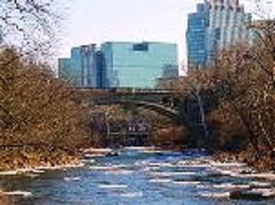
From the heights of Fort Washington Park, the shores of the Potomac River frame the skyline of the nation’s capital with the Washington Monument jutting toward the sky. Today, the city is a seat of national and international power, backed by an enormous military force with missiles, warships, aircraft and hundreds of thousands of soldiers at its disposal.

In 1809, it was defended by the earthen walls of Fort Washington, the ditch at its base and the cannons that lay inside. The fort was small, but well positioned on an outer bend of the Potomac River in Maryland, just a few miles south of the capital. Washington DC has changed dramatically over time, and the fort has too. The original structure, destroyed in 1814, was replaced by a brick fort in 1824 and later enlarged to include the long, massive walls that loom over the river today.

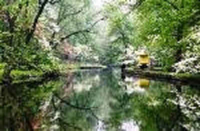
Fort Washington has enjoyed a remarkably peaceful riverside presence for more than 200 years. “It was never fired upon, and it never fired a shot in anger either,” said National Park Service ranger Barbara Wadding. Today, Fort Washington is a historic site and public park in the Chesapeake Bay Gateways Network and the Star-Spangled Banner National Historic Trail. Its 900-acre grounds include a 3-mile foot trail, paved bike lanes on the main road, picnic areas, woods and meadows. Fishermen gather constantly near the base of the Fort Washington lighthouse on the Potomac River. Birders visit, too, enjoying the frequent sight of eagles, bluebirds, kestrels and shoreline species like blue heron and osprey.

Urban life seems far away. Combined with the neighboring properties of Piscataway Park and National Colonial Farm, the shoreline here is quivering with the tender green leaves of spring. Downstream, on the Virginia side of the river, is George Washington’s historic estate, Mount Vernon. In morning light, its red roof can be seen through the trees from Fort Washington.

Fort Washington Park Main GateGeorge Washington often crossed the river to visit this site, which was home to the Digges family, and repeatedly urged that a fort be built here

The United States had barely finished its war for independence, and tensions with Britain ran high. The Chesapeake Bay had long served as a productive means of trade and travel, but it also provided an effective approach for the powerful British navy. Its rivers ran like exit ramps toward American cities, including Washington itself.

The Potomac River was the most obvious route to the capital, but George Washington saw a way to defend it — from Digges Point. “He knew the river, and he knew this part of the channel is unique,” Wadding said. The deepest part of the river swings east along the bend, forcing larger ships to move toward the Maryland shore, closer to the fort and its cannons. “This was the most defensible part of the river, before it goes upstream and widens,” Wadding said.

Fort Washington 1812Fort Washington has enjoyed a remarkably peaceful riverside presence for more than 200 years (Dave Harp)

The fort was built about 10 years after Washington’s death and originally called Fort Warburton. It took only five years before British warships did appear on the horizon. It was August 1814, and the War of 1812 was reaching its peak. The British were advancing on Washington. Thousands of troops landed along the Patuxent River in Southern Maryland and began marching inland. Others came by ship on the Potomac. American leaders believed the Potomac would deliver the thrust of the attack and realized too late that the real threat would arrive by land. On Aug. 24, after a brief battle at Bladensburg, MD, the British arrived in Washington and set fire to most public buildings, including the Capitol and the White House. But their ships hadn’t arrived. “The river is tidal, and it put them behind schedule,” Wadding said. British soldiers reversed their march. Three days later, seven British warships appeared on the river near Mount Vernon.

Inside Fort Warburton, U.S. Capt. Samuel Dyson had some problems. Dyson had taken command of the fort only 10 days earlier. He had 56 men. The cannons had not been tested — many of the gun stations were incomplete and installed on uneven platforms. Dyson estimated that they would only be able to fire about five of the guns from inside the fort and two from a small blockhouse.

South Branch Potomac RiverTo make matters worse, British foot soldiers were rumored to be marching toward the fort to help their warships with an attack. Dyson and his officers took a vote. They agreed to destroy the fort rather than allow the British to capture it. They made an exit plan, then lit 3,000 pounds of stored gunpowder.

The tremendous explosion leveled the fort. The British then sailed upriver to Alexandria, VA, where they captured 21 vessels and raided local warehouses before rejoining the rest of the fleet and moving on to Baltimore.

Dyson’s supervisors weren’t happy with his decision or its outcome. After being court-marshaled for abandoning post and destroying government property, he was dismissed from service. The fort, however, rose again, this time with the increasingly popular name of Fort Washington. The most distinctive change was placing the fort on the bluff, rather than using the low ground by the river. “It was completely redesigned with a larger, new shape and a smaller water battery close to the shore,” Wadding said.

Today, the fort has a castle-like presence, a brooding river guardian with thick high walls and a dry moat. Guests enter the grassy courtyard through a decorative arch, where gears and pulleys mark the operation of a drawbridge that no longer exists. Although the fort was in active military use through 1946 and spawned hundreds of buildings and tent quarters on the surrounding grounds, the interior of the old fort retains a much older feel. The guard rooms on either side of the gate feature fireplaces and worn wooden floors. Light filters through tall windows, but the prison cells are dank and dismal. Along the interior parade grounds, the barracks and officers’ quarters are a paired set of two-story brick buildings, each with a tiered white porch. Modern military aircraft occasionally roar overhead, oddly matched by the eagles and osprey that weave through the air with fish in their talons.

Mt Vernon Aerial CREDIT LautmanWadding looks at the brickwork and the cannon stations, which are mostly empty, and sees signs of endless change and adaptation. Over and again, engineers tinkered with the fort to change the types and numbers of guns, update water and power sources, and convert parts of the fort to new uses. In the late 1800s, defensive batteries of steel and concrete were built around the fort’s exterior. Their crumbling remains, including a gun tower, exist in the park today.

When the Spanish-American War began in 1898, an electrified minefield was laid down in the Potomac River. Fort Washington housed the generator. But not all the changes had a military purpose. Some just made life more comfortable. For example, the well water turned brackish shortly after the new fort opened, so the residents installed cisterns to collect rainwater. In the 20th century, the vault of one cistern was re-purposed to house a power source for the barracks. Casements on the fort’s lower level were intended for cannons, but one was quickly abandoned. “The ventilation system did not function well and you ended up with roomfuls of smoke,” Wadding said. “They used it for storage and laundry.”

Another casement may never have housed guns at all. “There’s no evidence they ever put them in there,” Wadding said. “But there is evidence they turned it into a bakery.”

Fort Washington MapFort Washington became home to the capital’s honor guard and was also used for a variety of training purposes. Historic photos in a park exhibit show the impressive colony of buildings and people that once filled its grounds. Now, all but three of the buildings that grew up around the fort are gone. An old home and aging gymnasium, both sealed up and closed to the public, sit near the park entrance. A yellow brick house, built in 1921 for the fort’s commander, is perched above the river next to the fort and serves as the visitor center. As the fort lost buildings and people, the upstream metropolitan area continued to grow. Today, Fort Washington has delivered a public benefit that was never part of its plan – a large swath of preserved green space along an intensely developed urban corridor where people can walk their dogs on a riverside trail, cast a fishing line and imagine a time when this spit of waterfront land could help the nation feel secure.

Fort Washington Lighthouse a guiding light has stood at Fort Washington since 1857, when a pulley system was used to raise an oil lamp to the top of a light pole. The 32-foot lighthouse that operates on site today was originally a fog bell tower that was installed in 1882 and was modified to include a light in 1901. The interior of the Fort Washington Lighthouse is open to visitors during the annual Maryland Lighthouse Challenge.

A Travel Plan to Visit

Fort Washington Southern Maryland Alexandria VA and Washington DC

Arezza Bot


America · Atlantic Coast · Cultural Heritage · Historic Towns · intercity transit · museums · travel plan

The Chestnut Hills Neighborhood of Philadelphia

8501Germantown Ave Cress HotelChestnut Hill is a beautiful award-winning neighborhood in northwest Philadelphia renowned for its gardens, art and architecture, parks, shopping, dining and many diverse, culturally enriching experiences.


Philadelphia’s Garden District Chestnut Hill is home to the Morris Arboretum situated on 92 lush acres and listed on the National Register of Historic Places and recognized as the official arboretum of the Commonwealth of Pennsylvania.  Its garden features the Azalea Meadow, the Japanese Hill and Water Garden, the Rose Garden, Step Fountain, Madeleine K. Butcher Sculpture Garden, and the Swan Pond.

The Tree Adventure a Bird’s Nest with a Bird’s Eye View of the Forest from 50 feet

Valley Green Bridge on the WissahickonThe neighborhood is nestled along the 1,800 acres of Wissahickon Valley Park, part of Philadelphia’s 9,200-acre Fairmount Park with biking, hiking, fishing in season, horseback riding and picnicking.  For nature enthusiasts, one of the special attractions of the park is the Thomas Mill Road Covered Bridge which is the only remaining covered bridge in the Wissahickon.  Not far from the bridge is the path leading to the 15 ft high statue of a kneeling Lenape warrior sculpted in 1902 by John Massey Rhind to commemorate the passing of the native Lenape from the region.

Thomas Mill Covered BridgeOne of the most popular destinations in the park is the historic Valley Green Inn, built in 1851.  It is the last remaining example of the many roadhouses and taverns that served and watered the carriage trade along the Wissahickon in the 19th Century; the Inn is still serving delicious meals today.

Woodmere MuseumThe Woodmere Art Museum is housed in a beautiful Victorian mansion; it focuses on the art and artists, both historical and contemporary, of the Philadelphia region.  Among the artists represented are Violet Oakley, Benjamin West, Arthur Charles, and N.C. Wyeth.  There are also juried exhibits of local painters and sculptors, solo shows of promising newcomers, and sculptures displayed on its grounds.

Enjoy Jazz on Fridays and Classical Music on Sundays at the Museum

The architecture of Chestnut Hill comprises one of the best collections of 19th and early 20th century residential buildings in the country, from the early Italianate designs of Samuel Sloan, to the exuberant Queen Ann buildings of G.W. & W.D. Hewitt; from the groundbreaking European-influenced work of Wilson Eyre to the exquisitely designed country houses of Mellor Meigs and Howe; and from the ornate classical design of Horace Trumbauer to the early modern works of Louis J. Kahn and Robert Venturi.

Shopping in Chestnut HillShopping and dining are the cornerstones of life in Chestnut Hill.  Germantown Avenue, the cobblestoned street that runs through the heart of the neighborhood, is lined with more than 85 shops including one-of-a-kind boutiques, an old-fashioned hardware store, home furnishings, art galleries, antique shops, a garden center and flower shops, farmers markets, spas and more.  Dining options also abound, with both casual and sophisticated restaurants, taverns and cafes offering a variety of American and ethnic dishes.

Chestnut Hill SEPTAFestivals Chestnut Hill hosts theHome & Garden Festival in the spring, a Fall for the Arts Festival in October, and a Harry Potter Festival, also in October.   When winter comes, the street is transformed for the holidays, with garlands of pine around shop windows and lamp posts, barrels filled with berries and greenery, and thousands of twinkling white lights decorating the trees.  Roasted chestnuts, carolers, brass quartets and special shopping nights are part of the holiday tradition in Chestnut Hill.

A Town for all Seasons

Your Travel Plan to Chestnut Hill and Philadelphia

Arezza Bot

America · Atlantic Coast · canals · Cultural Heritage · cultural itineraries · destination management · Friends and Family Travel · Historic District · Historic Towns · intercity transit · Maritime Heritage · museums · Travel · travel plan · waterways

Historic Towns on the Maryland Eastern Shore

Saint Michaels Chestertown Cambridge Salisbury and Oxford

The Eastern Shore of Maryland is comprised of nine counties with a population of nearly 450 thousand. The term Eastern Shore distinguishes a territorial part of the State from the land west of Chesapeake Bay.

Chesapeake Bay Maritime MuseumThe Chesapeake and Delaware Canal was a shallow canal with locks after its construction in 1829; it was deepened in the early 20th century to sea level. The north-south section of the Mason-Dixon Line forms the border between Maryland and Delaware. The border was originally marked every mile by a stone, and every five miles by a crownstone. It was surveyed as a compromise solution to a century-long wrangle between the Penn and Calvert families. Commercial east-west ties between Delaware and Maryland towns were culturally significant in Colonial and Early American periods despite the border line. Trade with Philadelphia was conducted by overland routes to Delaware towns like Smyrna and Odessa; these cultural connections continue to this day.

Downtown Saint Michaels, MarylandSaint Michaels derives its name from the Episcopal Parish established in 1677 which attracted settlers that grew tobacco and engaged in shipbuilding. The town’s tourist industry has roots in the 19th century with steamboats from Baltimore and summer guest cottages opening for weeklong rentals. The opening of the maritime museum in 1965, waterfront activities and historic bay vessels added further impetus to travel and vacations to the town.

High Street Chestertown MD

Chestertown was founded in 1706 and achieved prominence as one of six Royal Ports of Entry becoming Maryland’s second port after Annapolis and second to the State Capital in the number of 18th century mansions owned by a flourishing merchant class along the Chester River waterfront. In May 1774, five months after the British closed the port of Boston after the Boston Tea Party, the citizens of Chestertown wrote a set of resolves that prohibited the buying, selling, or drinking of tea. Based on these resolves, a popular legend has it that the citizens held their own tea party on the Chester River, in an act of colonial defiance.

The Chestertown Tea Party Festival celebrates Chestertown’s colonial heritage with a weekend of events with colonial music and dance, fife and drum performances, puppet shows, colonial crafts demonstrations and sales, military drills, and a walking tour of the historic district. In the afternoon, re-enactors board the schooner Sultana and tea is thrown into the Chester River.

Cambridge Municipal Building

Cambridge was settled by English colonists in 1684 who developed farming on the Eastern Shore. The largest plantations were devoted first to tobacco, and then mixed farming. The town was a trading center and later a stop on the Underground Railroad, an extensive network of safe houses for slaves escaping to the north. Cambridge developed food processing industries in the late 19th century, canning oysters, tomatoes and sweet potatoes.  Main Street is a comprehensive downtown revitalization process created by the Maryland Department of Housing and Community Development with a focus on heritage tourism.

Salisbury is the largest town on the Eastern Shore and the commercial hub of the Delmarva Peninsula. The town’s oldest neighborhoods have Federal, Georgian, and Victorian architecture.

Salisbury MD Main StreetOxford traces its start from 1666 when 30 acres were laid out as a town called Oxford by William Stephens, Jr. enjoying prominence as an international shipping center surrounded by wealthy tobacco plantations. Early inhabitants included Robert Morris, Sr., who greatly influenced the town’s growth; his son, Robert Morris, Jr., known as the financier of the Revolution; Jeremiah Banning, sea captain, war hero, and statesman; The Reverend Thomas Bacon, Anglican clergyman who wrote the first compilation of the laws of Maryland. Oxford has the oldest privately-operated ferry service still in continuous use in the United States originally established in 1683.

Reduce Transit Times and Travel Costs on Your Next Trip

Travel Plans     Intercity & Local Transport

Arezza Bot